Bieda and Mægla

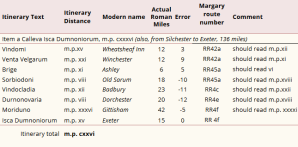
Under the year 501, the Anglo-Saxon chronicle states:

Her cuom Port on Bretene 7 his .ii. suna Bieda 7 Mægla mid .ii. scipum on þære stowe þe is gecueden Portesmuþa 7 ofslogon anne giongne brettiscmonnan, swiþe ęþelne monnan.

Here Port and his 2 sons, Bieda and Mægla, came with 2 ships to Britain at the place which is called Portsmouth, and killed a certain young British man – a very noble man.

jebson t., 2007, asc a. swanton, m., 2000,14.

As explained in The Anglo-Saxon Chronicle and Arthur’s death, this event would have taken place in the year 539 and refers to the battle of Camlan. It is proposed that the Briton referred to was Arthur.

Bieda

The Germanic name Bieda survives in the Portsmouth area in the placename Bedhampton.

Norden J., 1595.

It is mentioned in the Domesday Book with the name Betametone:

It was originally a village but is now a suburb of the Borough of Havant. The name appears in the placename Biedanheafde (Bieda’s Head) in the ASC under the year 675 when the West Saxon king Æscwine defeated the Mercian invasion by Wulfhere.

Mægla

Swanton maintains Mægla is probably a British name citing the names Coinmægl and Farinmægl that appear in the ASC entry for year 577. Mægla may be identified with Gildas’s tyrant Maglocunus, that is Maelgwn of Gwynedd, whose death is recorded in the Annales Cambriae under the year 547:

AC A textAC B text
[a103] annus . Mortalitas magna inqua pausat mailcun rex genedotœ .[b575] Anus mortalitas magna fuit ín brítannia mailguin · guíneth · obiit· vnde dicitur hir hun wailgun en llís Ros · tunc fuít lallwelen
Gough-Cooper, H.W., 2015, Annales Cambriae.

Gildas’s refers to Maelgwn’s aggression:

Quid tu enim, insularis draco, multorum tyrannorum depulsor tam regno quam etiam vita supra dictorum, …

And thou, the island dragon, who hast driven many of the tyrants mentioned previously, as well from life as from kingdom, …

WILLIAMS H., 1899, 76,77.

The first poem in the Llyfr Du Caerfyrddin (Black Book of Carmarthen), entitled Ymddiddan Myrtin a Talyessin (The Dialogue of Myrddin and Taliesin), informs us that Maelgwn made an attack on Dyfed:

Skene W.F., 1868, Ymddiddan Myrtin a Talyessin.

Triad 1a indicates the Demetian Arthur was a contemporary of Maelgwn:

Arthur in Pen Teyrned ym Mynyw, a Dewi yn Pen Esgyb, a Maelgwn Gwyned yn Pen Hyneif;

Arthur as Chief of Princes in Mynyw (St David’s), and Dewi as Chief of Bishops, and Maelgwn Gwynedd as Chief of Elders.

Bromwich R., 2006, 1.

Culhwch, on meeting Arthur, addresses him as Pen Teyrned yr Ynys hon (Chief of Princes of this Island). However, according to the V. Cadoci:

In diebus itaque illius rex quidam, nomine Mailgunus, in tota Brittannia regnabat, …

In his (St Cadog’s) days a certain king, Maelgwn by name, was reigning over all Britannia (Wales), …

wade-evans a.w., Lloyd s. (ed.), 2013,72, 73.

Perhaps, Maelgwn’s attack on Arthur’s Dyfed was not entirely successful and that later, with Saxon help, he achieved Arthur’s demise in Dumnonia at Camlan, thus achieving supremacy over the whole of Wales. Perhaps as a celebration of this victory, three places in Gwynedd bear the name Camlan as indicated by the red markers in the map below.

Camlan placenames in Gwynedd. OS data © Crown copyright and database rights 2024.

The arrival of the South Saxons and West Saxons

Cymenesora

Under the year 477, the Anglo-Saxon chronicle states:

Her cuom Ęlle on Bretenlond 7 his .iii. suna, Cymen 7 Wlencing 7 Cissa, mid .iii. scipum on þa stowe þe is nemned Cymenesora, 7 þær ofslogon monige Wealas 7 sume on fleame bedrifon on þone wudu þe is genemned Andredesleage.

Here Ælle and his 3 sons, Cymen and Wlencing and Cissa, came to the land of Britain with 3 ships at the place which is named Cymen’s Shore, and there killed many Welsh and drove some to flight into the wood which is named the Weald.

jebson t.,2007. swanton m., 2000, 14. asc A.

Mawer and Stenton identified Cymenes ora, Cymen’s shore, as the Owers in Selsey, Sussex. The names Malt Owers, Middle Owers and Outer Owers are located on the Admiralty Charts off the coast of Selsey Bill. Cimen shore is also marked on a 17th c. map:

Morden R., 1695.

Cerdicesora

For the year 495 we have the entry:

Her cuomon twegen aldormen on Bretene, Cerdic 7 Cynric his sunu, mid .v. scipum in þone stede þe is gecueden Cerdicesora 7 þy ilcan dæge gefuhtun wiþ Walum.

Here two chieftains; Cerdic and Cynric his son, came to Britain with 5 ships at the place which is called Cerdic’s Shore and the same day fought against the Welsh.

jebson t.,2007. swanton m., 2000, 14. asc A.

The landing site appears in variant forms: Cerdices ora (C) Certicesora (E). Its location is proposed the Ower in Hampshire:

The Ower at Calshot.

This location, the junction of Southampton Water and the Solent, has been considered a strategic site even till today.

Calshot spit and castle. © Hamphire County Council.

The birth of Wessex

As explained in The Anglo-Saxon Chronicle and Arthur’s death there are a number of entries in the Anglo-Saxon Chronicle for the period late 5th to early 6th c. which have been moved backwards in time by one or two Metonic cycles:

FictitiousHistoricalEvent
495, 514533Cerdic and his son Cynric arrive in Britain at Cerdic Shore.
500, 519538Cerdic and Cynric succeed to the kingdom of Wessex. Battle at Cerdic’s Ford.
501539Port and his sons Bieda and Mægla arrive in Britain. (Battle of Camlan)
508, 527546Cerdic and Cynric fight at Cerdic’s Wood. They kill king Natanleod and 5000 men. Land as far as Charford named Netley.
530549Cerdic and Cynric take the Isle of Wight, killing a few men at Wihtgar’s stronghold.
534553Cerdic dies. Cynric rules for 26 years. Isle of Wight given to nephews Stuf and Wihtgar.
544563Wihtgar dies and is buried at Wihtgar’s stronghold.
Dates of events in early Wessex.

Listing of the locations in the Count of the Saxon Shore

The officers and units under the command of the count are listed, together with their location, in the Notitia Dignitatum (Register of Offices) thus:

Praepositus numeri Fortensium, Othonae
Praepositus militum Tungrecanorum, Dubris
Praepositus numeri Turnacensium, Lemannis
Praepositus equitum Dalmatarum Branodunensium, Branoduno
Praepositus equitum stablesianorum Gariannonensium, Gariannonor
Tribunus cohortis primae Baetasiorum, Regulbio
Praefectus legionis secundae Augustae Rutupis
Praepositus numeri Abulcorum Anderidos
Praepositus numeri exploratorum, Portum Adurni

Rivet a.L.f., Smith C., 1979, 219.
LocationIdentificationLongitudeLatitude
OthonaeBradwell-on-Sea0.894751.7229
DubrisDover1.313451.1279
LemannisLympne1.025651.0752
BranadunoBrancaster0.638952.9624
GariannonorBurgh Castle1.659752.5863
RegulbioReculver1.213851.3781
RutupisRichborough1.324951.2959
AnderidosPevensey0.339750.8209
Portum AdurniPortchester-1.138250.8495
Table of the coordinates of the located sites.
Chart of the located sites. Click image to enlarge.

By examining the latitude values for the sites which are listed in the above table, it becomes clear they are largely decreasing in value as one progresses down the list. However, the first three locations, namely Othonae (Bradwell-on-Sea), Dubris (Dover) and Lemannis (Lympne), form one sequence which runs southwards down the coastline. The remaining six sites form a distinct continuous sequence also following the coastline. This may indicate two sources for the list, arising from two periods of fort construction.

Cornwall and Devon on the Gough map

Although most of the surviving elements of Tintagel castle, built by Richard Earl of Cornwall, in the 1230s are today on the mainland it is interesting that the Gough map locates it on the island, see image below.
[Click image to enlarge]

Detail from facsimile of Gough Map, Ordnance Survey .

Perhaps, this was because the main part of the castle, the Great Hall, was located there.

Tintagel castle Great Hall, English Heritage.

That fell into ruin by 1337 which perhaps lends support to the suggestion that the map’s prototype dates from c. 1280.

The map labels Totnes as Dertesmour and refers to Brutus’s landing there. Motland appears to refer to Looe Island. A label by it is now indecipherable but may well have been referring to the legend that Joseph of Arimathea and the child Christ landed there. Celly is the Isles of Scilly.

Looe island.

Antonine Iter XV

The first two columns of the table below show route Iter XV in the Antonine Itinerary.

The Roads of Roman Britain, Iter XV, Mike Haken, CC 2.0.

Based on the interpretations of the placenames as given in column three, it appears to be the most corrupted of the routes. For example, the total distance is said to be 136 (cxxxvi) miles whereas the distances between the modern places names add up to 126. However, with the addition of three stations, shown in red in the table below, the distances in the document can no longer be considered as largely erroneous bearing in mind that they are rounded to the nearest Roman mile.

Iter XV Roman miles
Statute miles Location Location distance
Discrepancy
Calleva Silchester
Vindomi 15 13.8 Egbury Castle 14.1 -0.3
unknown name 3 2.8 Devil’s Ditch 3.2 -0.4
Venta Velgarum 21 19.3 Old Sarum 18.9 0.4
Brige 11 10.1 Bokerley Ditch 10.6 -0.5
unknown name 4 3.7 Cursus 3.2 0.5
Sorbiodoni 8 7.4 Badbury Rings 7.8 -0.4
Vindocladia 12 11.0 Weatherby Castle 11.2 -0.2
Durnonovaria 8 7.4 Dorchester 8 -0.7
Muriduno 36 33.1 Seaton 32 1.1
unknown name 8 7.4 Sidford 7.0 0.4
Isca Dumnoniorum 15 13.8 Exeter 14 -0.2

Col. 1: Itinerary name.
Col. 2: Itinerary distance in Roman miles given in Hindu-Arabic numerals.
Col. 3: Itinerary distance converted into statute miles.
Col. 4: Modern name for the suggested location.
Col. 5: Distance to the suggested location in statute miles.
Col. 6: Discrepancy between the itinerary and location distances in statute miles.

Note, the distance from Silchester to Exeter is now 141 (cxxxxi) Roman miles. This would suggest that the AI cxxxvi was the result of the final x being misread as a v. A major reinterpretation is of Venta Velgarum being identified with Salisbury instead of Winchester. Sorbiodoni is Badbury Rings, the site of the battle of Badon, see Badbury Rings. The name possibly is a derivation of Caer Vadon. Vindocladia’s identification with Weatherby Castle gains support from its description on Pastscape:

“The earthwork remains of Weatherby Castle, a small multivallate hillfort comprising two roughly concentric ramparts and ditches, which enclose an irregular area on the highest part of a chalk spur.”

3.1 statute miles from Weatherby Castle is Winterborne Whitechurch a name which seems to contain the component Vindo-. Muriduno is located at Sidford with the nearby harbour at the mouth of the River Sid.

The Tyrrhenian sea

Tyrrhenian sea.

Our understanding of the name of this sea is that it is an area of the Mediterranean enclosed by the Italian peninsula and the islands of Sicily, Sardinia and Corsica. However, its use in the Historia Brittonum suggests a different body of water.

HB 15:
“He was expelled and wandered through Africa for 42 years and came to the Altars of the Philistines, past the Salt Lake and through Rusicade to the Mountains of Azaria and by the River Malva and through Mauretania to the pillars of Hercules, and sailed over the Tyrrhenian Sea and came to Spain, and there they lived for many years, and grew and multiplied exceedingly.”

This is a reference to the wanderings of a Scythian nobleman who had been expelled by the Egyptians for not having pursued the Israelites when they crossed the Red sea. His forces were intact whereas theirs were not and so the Egyptians feared he may exploit the situation. This chapter deals with the eventual colonisation of Ireland. The ‘ad Hispaniam’ of the text is an error for ‘ad Hiberniam’. The document suggests the Tyrrhenian Sea sea lay outside the Mediterranean.This chapter continues thus:

“After they had come to Spain and 1002 years after the Egyptians had been drowned in the Red Sea, they came to the lands of Darieta, at the time when Brutus was ruling amongst the Romans, with whom the consuls began, and then the Tribunes and the Plebs and the Dictators. The consuls, however, held the state for 447 years, which had previously suffered the rule of kings.”

Although the above translation of ‘Hibernia’ is given as ‘Spain’, it should have been ‘Ireland’ as was done in the first sentence of this chapter:

“If anyone wants to know when Ireland was inhabited and when it was deserted, this is what the chroniclers of the Gaels have told me.”

The territory called Darieta takes alternative forms in different versions of the Historia Brittonum:
C,D and L: dalrieta
G: dalriata
Q: dalricta
P: dalriete
This is clearly a reference to Dalriada, that is the Gaelic kingdom of Dál Riata. This would suggest the Tyrrhenian Sea is what is now known as the Irish sea, the body of water between Ireland and Britain. The fact that is surrounded by land masses may provide a basis for the name, for although it was called ‘Tyrrenum’ in the quoted version, other transcriptions had:
H, Mb: terrenum
Ma: terrenam[1]
L. Terrenus (adj.) means ‘earthly’.
This stretch of water is referred to again in HB 19:

“Then Julius Caesar, who had been the first to receive and hold sole power, was extremely angry and came to Britain with sixty keels and made land in the Thames estuary, where his ships suffered shipwreck, while he was fighting with Dolabella, who was Proconsul to the British king whose name was Belinus son of Minocan, who occupied all the islands of the Tyrrhenian Sea, and Julius returned without victory, his soldiers killed and his ships wrecked.”

The islands referred to as being ruled by Beli Mawr would have included the Isle of Man and some off the coast of Britain. The description of the Irish sea as surrounded by areas of land occurs at the end of HG 5:

“… ipse est uero olitauc dimor meton uenditus est.”
“He is in fact from Llydaw. He was sold to [the lands of] the Middle sea.”

This reference to Confer, the earliest name in that list of the rulers of Ystrad Clud, that is Strathclyde, in that list. OW meton gave MW mewn which can mean ‘(partly) enclosed by’, a fitting description for the Irish sea. Note, MW for the Mediterranean sea was Y Mor Canol.[2]

[1] Mommsen, T., 1898, 157.
[2] Evans, N., 2008, 28 n. 99.

Y Gogledd

The term Y Ogledd, the North, is taken to cover N. England and S. Scotland. The document BGG has a number of pedigrees unrelated to these areas. The obvious instance is the last one which includes Amlawdd Wledig. However, there are others like the one for Rhydderch Hael and Elffin and, therefore, I believe the term would have covered places like Gwynedd. It is claimed that the Welsh took stories from N. Britain and transferred them into Wales. This conjecture is incorrect as Y Gogledd would have included N. Wales.